A bike which passed mine on my commute this morning bore the campaign sticker "space for cycling".
"Where and what could this space could be?" went through my head. A physical space and / or a psychological space? Private space, public space, personal space, political space, on the road, on the calendar, on the footway?
Besides parks and squares, the highway is the public realm, where we commune in the contemporary city. The highway in the inner city is a street, with a significant public realm function, and is made up of footways and carriageways. Generally, wheeled vehicles use the carriageway, whether moving, standing or parked, while pedestrians - including wheelchairs and people pulling or pushing wheeled luggage or trolleys - use the footways, sometimes including the curtilages of streetfront properties.
Proposals by Transport for London for Kings Cross are ostensibly intended to "improve safety for cyclists" while maintaining traffic flow. As the 'Highway Authority' for red routes, TfL Engineers can ignore the LBI/LBC Place Plan. The TfL engineering approach evident here is to segregate lane allocation for cycles, although the impact on safety and flow are not proven. Visible and politically significant 'space for cycling' is supposedly provided by these painted green lanes.
Whether this improves 'flow' or 'safety' - for each category of road user and footway user in the highway - cannot be measured because the 'flow' excludes cycles and is measured by numberplate recognition APRN (TfL Traffic Modelling Guidelines 2010 p 22), the 'safety' is dependent on 'motorist lane discipline'. The roadside cycle lane increases the lanes on the carriageway from two to three, with the (painted) 'mandatory cycle lane' forming a third narrow lane, combined with ASZs at junctions. In parts, the proposed cycle lane spaces is taken away from the footway space, cutting into the areas where pedestrians can currently informally cross the carriageway. Network Rail, managers of the adjacent King's Cross Square have not commented.
Ultimately, additional lanes will create confusion for pedestrians arriving in the area from London's most cosmopolitan railway station complex, and will make the carriageway user lane allocations more complex, without providing demonstrable safety improvements for any road user. At a December 2013 inquiry into a fatal collision here, the coroner found no fault, suggesting "cycles and trucks do not mix", meaning that ultimately the carriageway would be dominated by the heavier commercially prioritised 'flow'. The inference by the distressed HGV driver in this collision at the inquest, was that a cycle lane may have made a difference. Truck drivers' blind spots were considered not unreasonable by police in the case, even where a cyclist may legitimately be crushed from behind if in a blind spot in front of an HGV in an advanced stop zone.
Just as pedestrian guardrail never provided protection from motorists, but prevented pedestrians from free movement onto the road, so lanes and ASZs are only as safe for cyclists pedestrians or any other carriageway user as the 'visually impaired' HGV drivers around them.
The Manual for Streets 2 (2010), the government's current guidance on the design of streets in built up and mixed use areas like King's Cross, states the principle that "pedestrians should be considered first" when "designing, building, retrofitting, maintaining, and improving" urban streets. This means walkable streets, clearly defined footways and with easy to cross carriageways of a minimum width and minimum speed. The TfL 'improvements' scheme for King's Cross contravenes this first principle, from the very first stage of the gyratory review scheme. The Highway authority could have a terrible effect on worsening our Town Centre.
Local MP Emily Thornberry will attend the supporters conference on 21 June in Kings Cross where we will look at the town centre gyratory. She recently asked the PM to intervene at Mount Pleasant where Mayor Boris Johnson is overriding the Local Authority - perhaps the same could be done for King's Cross Town Centre.
Saturday 15 March 2014
Tuesday 11 March 2014
Gyratory removal begins piecemeal and contrary to years of planning
Transport for London is consulting again on the Gyratory in King's Cross (town centre), after a wishy-washy set of "objectives" were published last year(1).
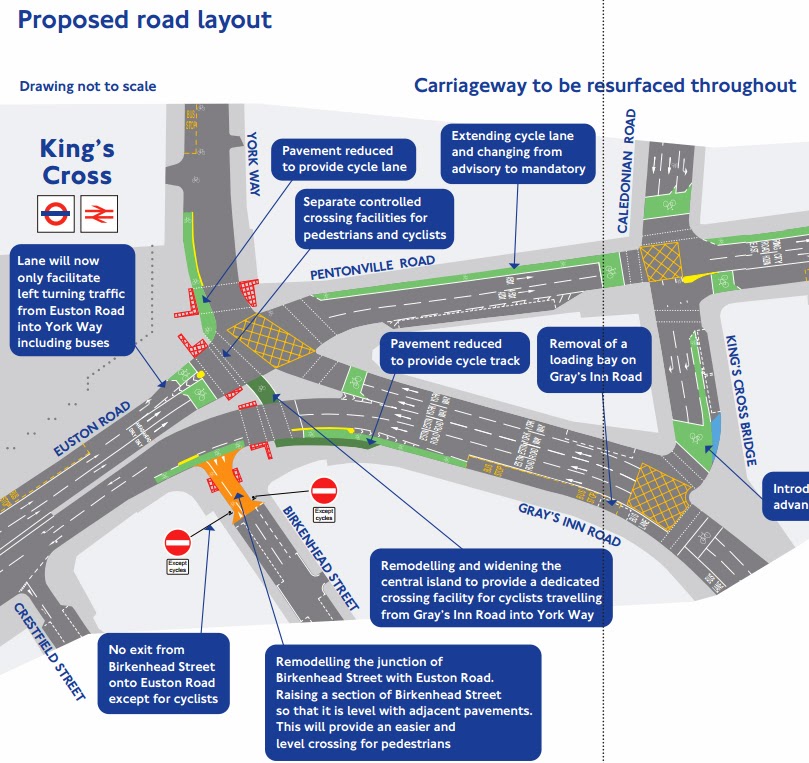
The latest consultation began by proposing some new cycling infrastructure. The Mayor's strategy of marking cycle lanes is infuriatingly tokenistic, and in this case, also cuts into already crowded inner city footways near the station. A Place-Shaping plan for this increasingly cosmopolitan area has been developed painstakingly over several years, and is now naively overruled, with TfL cutting away at the pedestrian realm and town square. One of these proposed green lanes clashes with a bus stop, the King's Cross 'ghost bike' and a parish boundary marker which is hundreds of years old.
An approximately ten-metre long kerb-separated cycle lane is proposed in York Way, north of the dangerous junction, at the entrance to King's Cross Square, and is proposed to cut into the new pedestrian realm recently completed there as an overdue legacy of the 2012 Olympics.
The entire approach appears traffic-engineering led, while no assessment has been made of impact on the public realm, nor of potentially improving the walkability of this important town centre area, nor of applying TfL's own toolkit "Valuing Urban Realm". The consultation process was based on technical highway engineering plans, illegible to many, without three-dimensional or pedestrian views, and was attended predictably by a few residents and traffic nerds like myself. A tent could easily have been placed on the crowded pavement at King's Cross Square, for the cost of hiring the community room at KCBNA. This would have been visible to the thousands of people, visitors, shoppers, office workers, commuters and others who use the area daily.
 Attending the 'drop-in' session with Clare, the 'consultations delivery manager', the two well-meaning TfL traffic engineers, Lisa and Joanne, maintained that the two northbound lanes of Gray's Inn Road, merging through the junction where Min Joo Lee was killed, could not be reduced to one, because of the Mayors policy of 'Smoothing Traffic Flow'. (Neither expressed a willingness to personally walk or cycle through the area or junction, especially after our discussion)
Coroner Mary Hassell at the Min Joo Lee inquest, referring to this accident site, said that "cycles and HGVs do not mix", yet the design by TfL indicates otherwise. Advanced Stop Zone markings invite the unwary cyclist into the junction to 'mix' here, leading from Gray's Inn Road to York Way.
Joanne stated that the TfL traffic modelling boffins calculate that the 'Journey Time Reliability' impact of reducing the two lanes to one would be "11 minutes" for motorists on the gyratory. It is not TfL policy to consider pedestrian or cycle journey times. This ostensibly means the highway authority considers a journey time reliability variation of 11 minutes for 'commercial freight and buses' to be unacceptable, while accidents like the Min Joo Lee collision are unavoidable, and sadly seem repeatable here. This means that in King's Cross town centre, engineering is focussing on road space and maximising motor vehicle journey time reliability ('flow'), clearly at the cost of the public realm and better pedestrian environment (air quality, noise, walkability, shop viability and accessibility etc)
The two northbound carriageway lanes of Gray's Inn road at the Lighthouse site will inevitably be constrained when the island development re-opens with its narrow footways, so the idea that this 50 metre piece of northbound lane in Gray's Inn Road reduces traffic flow variability by 11 minutes seems spurious. Anyway, the two lanes suddenly merge in the (deadly) junction with Pentonville Road. York Way ahead is a single 20mph lane, with taxis pulling into the station at the proposed segregated cycle lane on the left.
The design approach so far has been entirely engineering led, and in clear discord with Manual for Streets 2, the government's 2010 street planning guide, which states that, where there is a public realm, such as near a railway station, "pedestrians needs should be considered first" (page 7). Instead, pedestrians have been excluded from the traffic modelling (and modelled separately with VISSIM, according to Joanne - but this contravenes TfL's own modelling guidelines). The engineers were oblivious to recent plans for improving adjacent Caledonian Road.
Pedestrians arriving by train from Europe and the whole of the UK would be confronted at the edge of King's Cross Square with a green painted cycle lane, a tripping kerb where taxis stop, and a countdown timer - the opposite of being considered first. The proposed pedestrian countdown timer will aim to further constrain normal pedestrian judgement, with the traffic engineer's wish that they will conform to more predictable behaviour like 'traffic'. Cyclists gain strips of green paint. What was the point of Bikes Alive again, after all? I think Boris didn't really 'get it'.
1. TfL "Objectives" for Kings Cross
The latest consultation began by proposing some new cycling infrastructure. The Mayor's strategy of marking cycle lanes is infuriatingly tokenistic, and in this case, also cuts into already crowded inner city footways near the station. A Place-Shaping plan for this increasingly cosmopolitan area has been developed painstakingly over several years, and is now naively overruled, with TfL cutting away at the pedestrian realm and town square. One of these proposed green lanes clashes with a bus stop, the King's Cross 'ghost bike' and a parish boundary marker which is hundreds of years old.
An approximately ten-metre long kerb-separated cycle lane is proposed in York Way, north of the dangerous junction, at the entrance to King's Cross Square, and is proposed to cut into the new pedestrian realm recently completed there as an overdue legacy of the 2012 Olympics.
The entire approach appears traffic-engineering led, while no assessment has been made of impact on the public realm, nor of potentially improving the walkability of this important town centre area, nor of applying TfL's own toolkit "Valuing Urban Realm". The consultation process was based on technical highway engineering plans, illegible to many, without three-dimensional or pedestrian views, and was attended predictably by a few residents and traffic nerds like myself. A tent could easily have been placed on the crowded pavement at King's Cross Square, for the cost of hiring the community room at KCBNA. This would have been visible to the thousands of people, visitors, shoppers, office workers, commuters and others who use the area daily.
Coroner Mary Hassell at the Min Joo Lee inquest, referring to this accident site, said that "cycles and HGVs do not mix", yet the design by TfL indicates otherwise. Advanced Stop Zone markings invite the unwary cyclist into the junction to 'mix' here, leading from Gray's Inn Road to York Way.
Joanne stated that the TfL traffic modelling boffins calculate that the 'Journey Time Reliability' impact of reducing the two lanes to one would be "11 minutes" for motorists on the gyratory. It is not TfL policy to consider pedestrian or cycle journey times. This ostensibly means the highway authority considers a journey time reliability variation of 11 minutes for 'commercial freight and buses' to be unacceptable, while accidents like the Min Joo Lee collision are unavoidable, and sadly seem repeatable here. This means that in King's Cross town centre, engineering is focussing on road space and maximising motor vehicle journey time reliability ('flow'), clearly at the cost of the public realm and better pedestrian environment (air quality, noise, walkability, shop viability and accessibility etc)
The two northbound carriageway lanes of Gray's Inn road at the Lighthouse site will inevitably be constrained when the island development re-opens with its narrow footways, so the idea that this 50 metre piece of northbound lane in Gray's Inn Road reduces traffic flow variability by 11 minutes seems spurious. Anyway, the two lanes suddenly merge in the (deadly) junction with Pentonville Road. York Way ahead is a single 20mph lane, with taxis pulling into the station at the proposed segregated cycle lane on the left.
The design approach so far has been entirely engineering led, and in clear discord with Manual for Streets 2, the government's 2010 street planning guide, which states that, where there is a public realm, such as near a railway station, "pedestrians needs should be considered first" (page 7). Instead, pedestrians have been excluded from the traffic modelling (and modelled separately with VISSIM, according to Joanne - but this contravenes TfL's own modelling guidelines). The engineers were oblivious to recent plans for improving adjacent Caledonian Road.
Pedestrians arriving by train from Europe and the whole of the UK would be confronted at the edge of King's Cross Square with a green painted cycle lane, a tripping kerb where taxis stop, and a countdown timer - the opposite of being considered first. The proposed pedestrian countdown timer will aim to further constrain normal pedestrian judgement, with the traffic engineer's wish that they will conform to more predictable behaviour like 'traffic'. Cyclists gain strips of green paint. What was the point of Bikes Alive again, after all? I think Boris didn't really 'get it'.
1. TfL "Objectives" for Kings Cross
- Improved safety for all road users, in particular pedestrian and cyclists
- Better balancing of traffic with the need to create an improved place to live, work and visit
- Improved accessibility for pedestrian, particularly for public transport and access to and from mainline stations x
- Maintain bus journey time, services and infrastructure
- Appropriate provision for taxis, private hire vehicles, servicing and freight
- Retention of journey time reliability and capacity on the Inner Ring Road
- Ensuring suitable provision for coaches and tour buses
- Improved environment for people who live and work in the area
(Detail of any improvement targets for noise and air quality, for the environment, and pedestrian permeability of the area have been ignored by TfL, as have the 2008 PERS audits)
Online Survey: https://consultations.tfl.gov.uk/streets/kingscross
My Response:
The footway is reduced and contravenes Manual for Streets 2 p 7.
The methodology for JTR assessment re lane consolidation G I Rd northbd appears flawed.
Pedestrian modelling has not been integrated per TfL Guidelines.
Cycle infrastructure proposals are tokenistic and will not demonstrably improve safety, may
worsen pedestrian and cycle safety.
Valuing Urban Realm Toolkit has not been applied.
Islington works for 2 way Caledonian Road are ignored.
LBC / LBI Place Shaping Plan 2012 has been ignored.
These proposals have now been built.


Other responses:
1 Cycling Embassy UK
2 MaidstoneonBike
Subscribe to:
Posts (Atom)